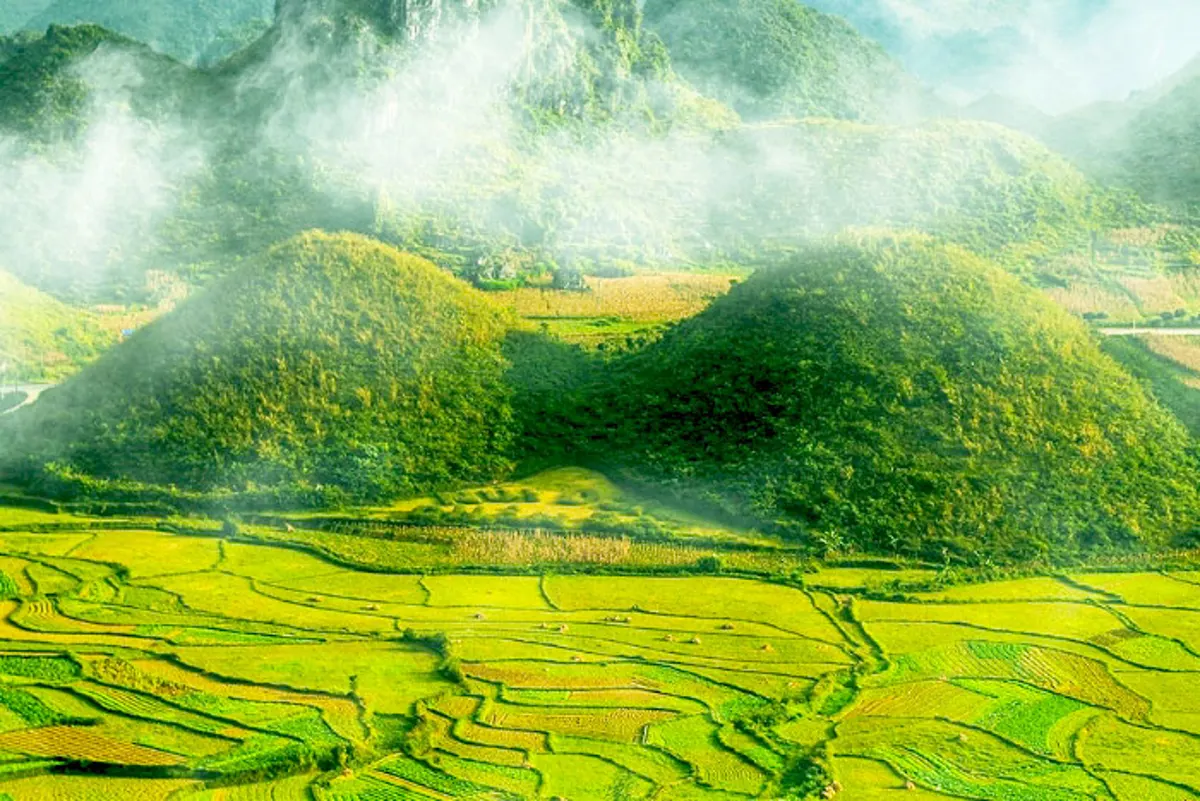
Ha Giang Province, located in Vietnam's northern mountainous region and sharing a border with China, spans approximately 7,900 square kilometers, predominantly covered by peaks and forests. This destination draws visitors primarily for its consistent pleasant climate throughout much of the year and its diverse cultural landscape. It presents an opportunity to experience a unique part of Southeast Asia.
An Introduction to Ha Giang Province
Ha Giang's geographical position contributes to its distinctive appeal. While part of a tropical nation, the province experiences weather patterns more akin to temperate zones, featuring cool, dry conditions and colder winters. This climate helps maintain the region's scenic beauty for most of the year, with roads often appearing to ascend towards the sky and terraced fields spreading across mountainsides and valleys.
The province's allure extends beyond its natural environment to its profound cultural depth. A significant majority of Ha Giang's inhabitants belong to various ethnic minority groups, including the Mong, Thai, Meo, Tay, and Kinh. This demographic composition allows visitors to observe and appreciate a wide array of traditional lifestyles and customs, offering insights into the diverse heritage of Vietnam.
Notable Natural and Historical Sites
Ha Giang is home to several significant sites that highlight both its geological importance and its historical narrative. These locations provide a comprehensive view of the province's character.
The Dong Van Stone Plateau stands as a prominent feature, presenting a landscape dominated by gray rock formations, often described with the local saying "living in stone, dying in stone." Recognized for its ancient geological history, this plateau was designated a UNESCO World Heritage Site in December 2010. Its unique environment offers a glimpse into Earth's distant past.
Within this stony expanse lies the Palace of Vuong, frequently referred to as a "green jewel" amidst the plateau. This architecturally distinctive residence, surrounded by mature trees, has been preserved through many decades, carrying with it compelling historical accounts. Construction of the Vuong palace began in 1919 and was completed ten years later. It is situated on a turtle-shaped hill, characterized by its distinctive form and the presence of tall, robust trees that frame the house against the sky.
Further north, the Lung Cu Flag Pole marks a symbolic point, often cited as "the starting point of the first drawing of the map of the country." This northernmost geographical marker is a destination many aspire to reach. The journey involves traversing 1.5 kilometers, ascending over 389 stone steps, and then climbing 140 spiral stairs inside the flag tower itself. At the summit, visitors find the Vietnamese national flag, measuring 54 square meters—a size symbolically representing Vietnam's 54 ethnic groups united.
The Road to Happiness is a historical route spanning 200 kilometers, constructed through the dedicated efforts of thousands of young volunteers. These individuals, representing 16 ethnic groups from eight northern provinces of Vietnam, worked for six years between 1959 and 1965, accumulating over 2,000 working days to complete the road. This monumental undertaking is remembered as a path forged with immense sacrifice.
A particularly challenging segment of this route is the Ma Pi Leng Pass, known for its rugged terrain and approximately 20-kilometer length. Ma Pi Leng is informally recognized as one of the "four great passes" in northern Vietnam's mountains, alongside O Quy Ho Pass, Khau Phau Pass, and Pha Din Pass. This section of the Road to Happiness represents a significant engineering achievement and a testament to human endeavor.
Ha Giang's Climate and Optimal Visiting Periods
Despite its location within a tropical country, Ha Giang experiences a climate that often feels more temperate. The weather is generally cool and dry for much of the year, with winters bringing noticeably colder temperatures. This consistent pleasant weather contributes significantly to the province's visual appeal, making it an attractive destination for most seasons.
However, prospective travelers should be aware of the region's flood season, which typically occurs from June through the end of August. During these months, heavy rains can lead to hazardous conditions, making travel unsafe. It is advisable to avoid planning trips to Ha Giang during this specific period to ensure safety and a more enjoyable experience.
Cultural Richness and Local Traditions
The cultural diversity of Ha Giang is a defining characteristic of the province. With ethnic minority groups constituting the majority of the population, including the Mong, Thai, Meo, Tay, and Kinh, the region offers a unique opportunity to engage with various traditional practices and ways of life. Each group contributes distinct customs, languages, and artistic expressions to the local fabric.
One notable cultural event is the Khau Vai Love Market. While specific details about its operation are not provided in the source, its mention highlights the unique social traditions found in Ha Giang. Visitors often find that interacting with local communities provides a deeper understanding of the region's heritage and the daily lives of its people. For those interested in local crafts, Vietnam offers a diverse array of traditional crafts perfect for souvenirs.
Planning Your Journey to Ha Giang
Visiting Ha Giang requires some preparation, especially given its mountainous terrain and the nature of its attractions. While the province is celebrated for its seasonal natural beauty, such as the "triangular circuit" flower season, every time of year outside the flood season offers something to appreciate.
Travelers often find that navigating the region involves significant road travel. For longer distances within Vietnam, considering overnight rail journeys can be an efficient way to cover ground before reaching Ha Giang. Once in the province, exploring the various sites often involves scenic drives and, in some cases, hiking. It is recommended to verify current road conditions and weather forecasts, particularly if traveling during shoulder seasons.
Key Attractions Overview
Here is a summary of the main attractions in Ha Giang, based on available information:
| Attraction | Description | Key Features | Operational Details |
|---|---|---|---|
| Dong Van Stone Plateau | An ancient geological formation covering a vast area. | UNESCO World Heritage Site (since Dec 2010), characterized by gray stone landscapes. | No specific hours or entrance fees provided. |
| Palace of Vuong | A historical residence situated amidst the stone plateau. | Built 1919-1929, surrounded by trees, preserved architecture, located on a turtle-shaped hill. | No specific hours or entrance fees provided. |
| Lung Cu Flag Pole | Vietnam's northernmost point and a symbolic national landmark. | Requires ascending 389 stone steps and 140 internal spiral stairs; features a 54m² national flag. | No specific hours or entrance fees provided. |
| The Road to Happiness | A 200km historical road constructed by volunteers. | Built 1959-1965 by 16 ethnic groups; includes the Ma Pi Leng Pass. | Accessible by road; no specific hours or entrance fees provided. |
| Ma Pi Leng Pass | A rugged mountain pass, part of the Road to Happiness. | Approximately 20km long, unofficially one of northern Vietnam's "four great passes." | Accessible by road; no specific hours or entrance fees provided. |
| Khau Vai Love Market | A cultural event reflecting local traditions. | Represents the diversity of culture in Ha Giang. | No specific dates, hours, or location details provided. Visitors should verify local schedules. |
Note: Specific addresses, phone numbers, opening hours, and entrance fees for these attractions were not supplied in the source material. Visitors are advised to check current information locally.
Frequently Asked Questions
What is the best time of year to visit Ha Giang?
The most favorable periods to visit Ha Giang are generally outside of the flood season, which runs from June through August. The province experiences a temperate-like climate for much of the year, with cool and dry conditions, making it visually appealing in many seasons. However, always check local weather forecasts before traveling.
What makes Ha Giang's culture unique?
Ha Giang's culture is distinguished by its significant population of various ethnic minority groups, including the Mong, Thai, Meo, Tay, and Kinh. This demographic composition results in a rich tapestry of traditions, lifestyles, and customs that visitors can observe and learn about, such as those associated with the Khau Vai Love Market.
Is Ha Giang suitable for all types of travelers?
Ha Giang primarily appeals to travelers seeking natural landscapes, cultural immersion, and adventurous road trips. Its mountainous terrain and the nature of its attractions, such as the winding Road to Happiness and the ascent to Lung Cu Flag Pole, suggest it is best suited for those comfortable with extensive travel by road and some physical activity.
What are some of the most important historical sites in Ha Giang?
Key historical sites include the Palace of Vuong, a preserved residence with a compelling past, and the Road to Happiness, a monumental construction project that reflects significant human effort. The Lung Cu Flag Pole also holds historical and symbolic importance as the northernmost point of the country.
Are there any specific safety considerations for traveling in Ha Giang?
The primary safety consideration for Ha Giang is avoiding the flood season, which occurs from June to August, due to potentially unsafe travel conditions. Additionally, given the mountainous roads, caution is advised when driving or riding, and checking road conditions before setting out is always prudent.